personas:brolin:capacitacion_sig:eafit_2016
¡Esta es una revisión vieja del documento!
Tabla de Contenidos
¿Cómo hacer accesibles los mapas históricos a la comunidad?
Título
http://piratepad.net/eafit2016
Como lo ha venido haciendo la biblioteca nacional
¿Y si no hemos podido rectificar aún, cómo compartir la imagen con otras personas?
- Zoomify
- Open Sea Dragon
- Formato especial Tiles1)
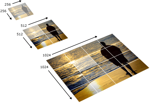
You have to provide the url to the Zoomify image folder and the with and height dimensions of the original image. You can also specify a display tolerance for the inital zoom level. A value lower than 1.0 might center the image and cut of the edges.\\The Zoomify tile format is similar to popular map tiling schemes, and I'm extending the Leaflet TileLayer class to show the image. The tiling follows a quadtree or pyramid pattern of increasing resolution, doubling the resolution for each zoom level. The tile size is 256 x 256 px and there are 256 tiles in each folder. The filename for each tile is z-x-y.jpg where z is the zoom level and x/y is the grid position starting from the top left corner.
Mapwarper
- pestaña de export
- Geotiff
- PNG
- KML
- WMS
- Tiles
Título
Procedimiento:
- Toma el enlace Tiles de mapwarper

- Lo carga en geojson.io


- Se marcan varios puntos en geojson.io


- Se descarga la información de geojson.io

- Se abre qgis y se carga en qgis los datos bajados de geojson.io

- Se ajustan las propiedades, como los íconos para cada imagen


- ¿Cómo cargar íconos?

- Se instala en qgis el complemento qgis2web


- Se exporta un .html con qgis2web usando dos mapas base


- Usar un editor de html, si es posible instalar atom.io

- Se reemplaza en el código .html uno de los mapas base con la dirección de tiles de mapwarper


- Así se debería ver el sitio web final

personas/brolin/capacitacion_sig/eafit_2016.1459371322.txt.gz · Última modificación: (editor externo)